
HABERSHAM COUNTY, Ga. — After heavy overnight rainfall triggered a Flood Advisory in parts of Habersham and Rabun counties, multiple rounds of strong thunderstorms continued to move across Northeast Georgia Sunday afternoon.
Speculation swirled on social media of a possible tornado near Hollywood in north Habersham County. However, Now Georgia weathercaster Tyler Penland said a check of the radar ruled that out. He did say, though, there was a possible downburst. Wind gusts ranged from 25 to possibly 50 mph across Habersham County as a severe storm rolled through.
The National Weather Service issued a series of Special Weather Statements as storms tracked east and northeast across the region, bringing the threat of damaging wind gusts, hail, frequent lightning, and heavy rain.
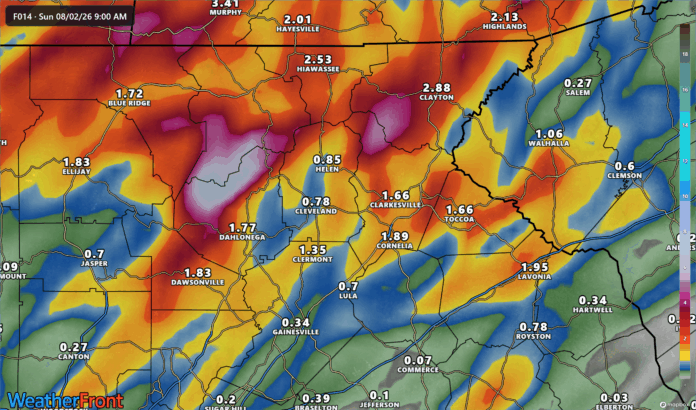
Additional rounds of showers and thunderstorms are expected through at least mid-week. Locally heavy rainfall and gusty winds will be possible each afternoon, Monday through Saturday, August 3-8.
Flooding concerns
The active weather follows heavy weekend rains that prompted a Flood Advisory for northwestern Habersham and Rabun counties. Between 1 and 3 inches of rain fell overnight, leading to minor flooding concerns in low-lying and poor drainage areas.
The National Weather Service urges residents to seek shelter indoors when thunderstorms approach and to stay away from open water. Lightning can strike up to 10 miles from a thunderstorm, even before rain begins.
Motorists should also use caution on wet roads and remember: Turn Around, Don’t Drown when encountering flooded roadways.
Don’t miss what everyone in town is talking about.
Join 4,000+ locals and choose our free newsletter covering news, events and the stories shaping our region.