

Winter Storm Fern continues to batter North Georgia, bringing many communities to a standstill as ice, sleet, and freezing rain create dangerous conditions across the region. Power outages are expanding, emergency operations are fully activated, and the list of area closings continues to grow.
Stephens County impacts grow
In Stephens County, 911 dispatchers reported a growing number of calls Sunday related to fallen trees and power lines, power outages, and hazardous travel as ice continued to accumulate. The Stephens County Sheriff’s Office said most roadways in the county are affected.
“We have not declared any official road closures at this time, but we are closely monitoring road conditions,” said Rebekah Smith, public information officer for the sheriff’s office.
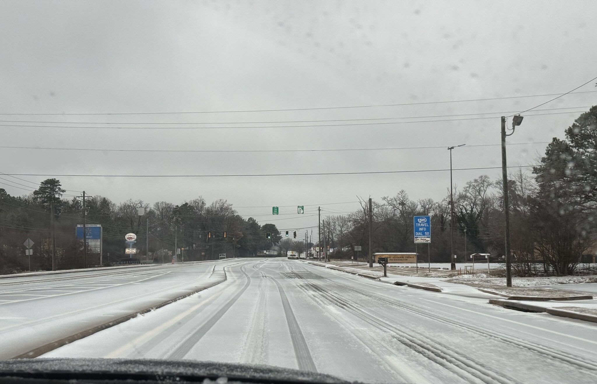
Emergency officials continue to urge residents to stay off the roads unless travel is necessary. Stephens County Emergency Management is providing live road condition updates as reports come into the Emergency Operations Center.
Poor road conditions hamper emergency response
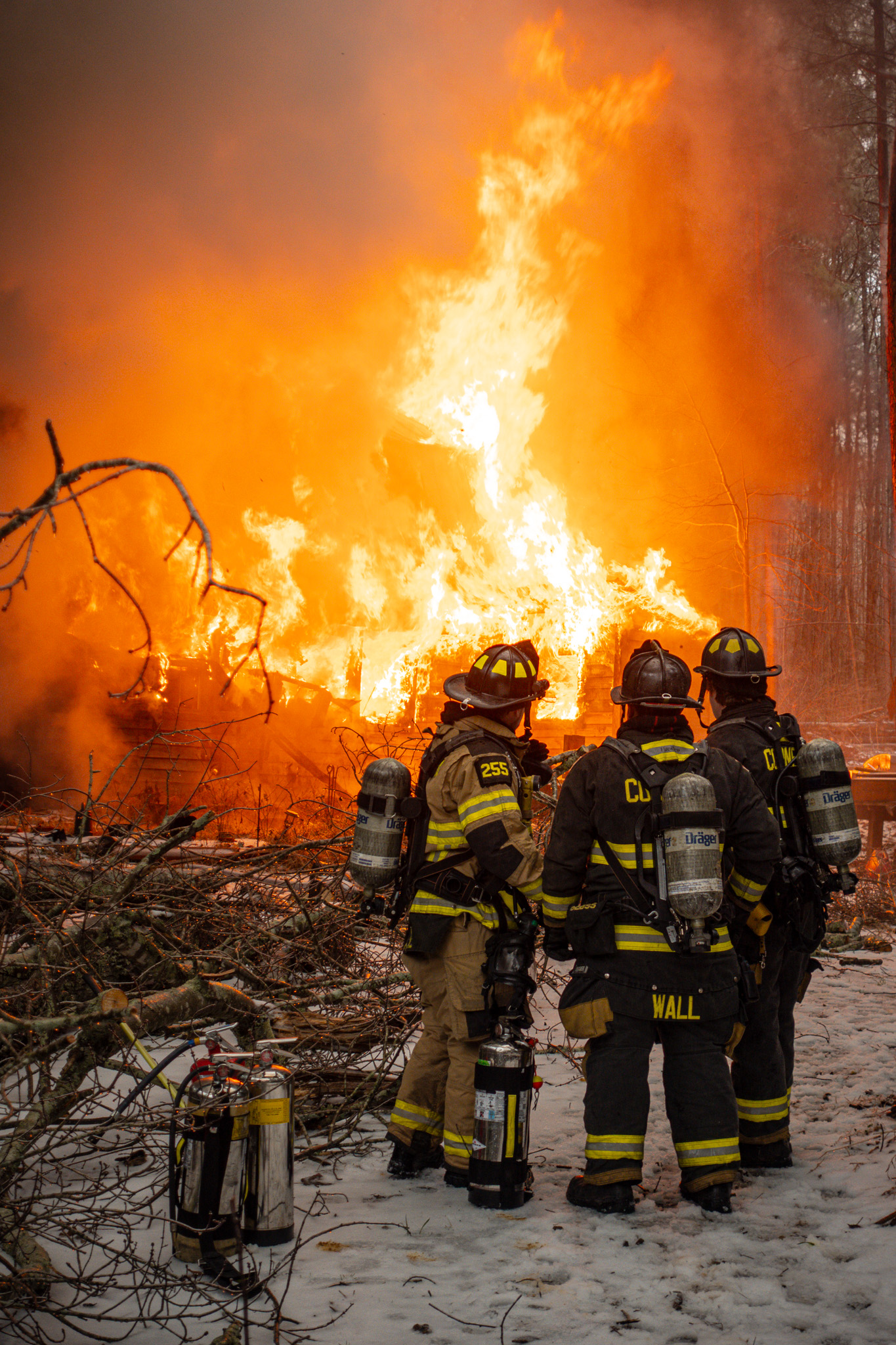
In neighboring Habersham, icy roads hampered local firefighters’ response to a residential fire on Welcome Home Road in Mt. Airy. Fire trucks were unable to travel to the scene safely. Personnel who could respond were limited to monitoring the house as it burned.
Around 1 p.m. Sunday, the county reported 22 trees blocking roadways, five of the on state routes. Several of those incidents involved downed power lines.
“Crews are working as quickly and safely as possible to clear roads, but as the storm continues to intensify, more trees are expected to fall,” said Habersham County Public Information Officer Ashlyn Brady. “We strongly encourage all citizens to stay home and avoid travel if at all possible.”
Officials are also urging the public to avoid clearing debris that could have downed power lines in it. Report downed trees blocking roadways to 911.
Habersham County Interim EMA and E-911 Director Melanie Bellinger said the storm impacted northern Habersham hardest. Winter Storm Fern dumped approximately a half-inch of sleet and up to a quarter-inch of freezing rain on the county. Early forecast totals called for up to an inch of ice in Habersham and Rabun counties, but NowGeorgia.com weathercaster Tyler Penland said sleet helped reduce that amount, at least initially.
RELATED Storm-related gas leak shuts down Clarkesville road
Power outages
By midday Sunday, about a third of Habersham EMC customers were without power, and Georgia Power’s outage numbers were growing. More outages were expected as a second band of freezing rain was forecast to pass through the area.
“Power outages start where it was mostly freezing rain. Cornelia saw more sleet than Clarkesville did,” he said, “and the outages were limited.” He said the true test will come after the second band of the storm’s wedge passes through.
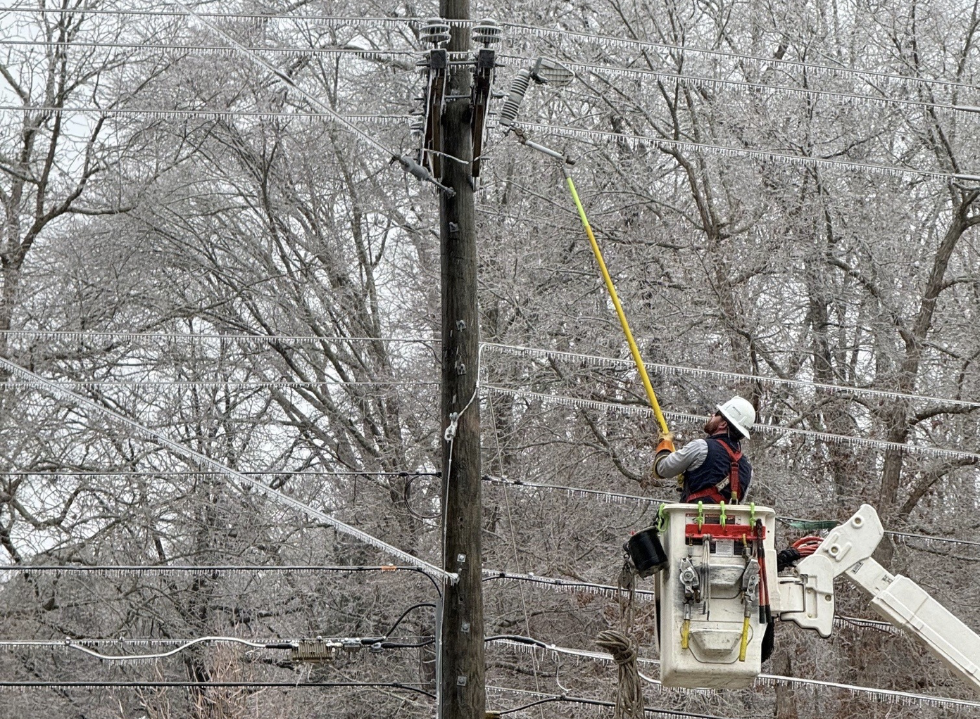
By midday Sunday, over a third of Habersham EMC customers were without power, and Georgia Power’s outage numbers were growing. Officials warn that additional outages are likely as another band of freezing rain moves through and gusty northwest winds arrive overnight into Monday.
With overnight temperatures expected to plummet into the low 20s, schools, government and medical offices, and many businesses have announced closings for Monday. A few have already announced plans to close on Tuesday.
A Cold Weather Advisory remains in effect from 4 a.m. to 10 a.m. Monday, Jan. 26. However, highs will barely reach above freezing, causing the remaining ice to linger, especially in shady areas.
White County at full emergency activation
Over in White County, officials said conditions were worsening Sunday afternoon as more freezing rain fell. Updated briefings from the National Weather Service confirm heavy freezing rain, gusty winds, and prolonged sub-freezing temperatures that are expected to extend impacts into at least Tuesday.
White County Emergency Management issued an updated Situation Report on Jan. 26, outlining the county’s emergency response. According to the Report, the White County Emergency Operations Center is at full activation and operating in the response phase, coordinating emergency operations, resource management, and situational awareness countywide.
Officials reported an early-morning commercial power interruption at the White County 911 Center and EOC on Sunday, tripping emergency power systems. Officials said operations were not disrupted and commercial power has since been restored.
Beginning around 8:30 a.m. Sunday, public safety agencies saw a sharp increase in calls related to downed trees and power lines, including property damage incidents. No injuries or entrapments had been reported as of mid-afternoon Sunday, said White County Public Information Officer Bryce Barrett.
State of Emergency
A State of Emergency remains in effect at the federal, state, and local levels, including a Presidential Declaration for Georgia, a statewide declaration issued by Brian Kemp, and local declarations from White County and the City of Cleveland.
Some counties opened shelters, and several state parks were used as warming stations ahead of the storm. A Cold Weather Advisory remains in effect from 4 a.m. to 10 a.m. Monday, Jan. 26. High temperatures are expected to struggle to reach freezing, allowing ice to linger.
Temperatures are expected to remain below freezing through Monday, with little to no melting anticipated before Tuesday. Travel conditions are expected to remain hazardous, particularly on untreated roads and shaded areas. Black ice from remains a serious threat.
North Georgia should see improved road conditions by Tuesday in the hardest hit areas, stretching from Dawsonville to Cleveland, Clarkesville to Clayton, and points southeast. In the meantime, residents are urged to avoid unnecessary travel, prepare for extended power outages, and closely monitor news and official channels for updated information.
NowGeorgia.com will continue to deliver updates throughout the storm here on our website and Facebook page.
RELATED


